

 (1)")

")

Upcoming Important Deadlines
| Event | Deadline | Status |
| Long abstract submission | Closed | |
| Notification of long abstract acceptance | Closed | |
| Full paper submission (based on accepted long abstracts) | Closed | |
| Short abstract submission | Closed |
")


Governor, Nairobi County
Welcome to Nairobi.
On behalf of the people of Nairobi and the Republic of Kenya, I extend our warmest greetings to all delegates, researchers, innovators and partners joining us for the joint International Society for Photogrammetry and Remote Sensing (ISPRS) Conference on Geo-digitisation for Sustainable Development Goals (SDGs) and the 3rd Youth Innovation Forum of Digital Earth. It is both an honor and a privilege for Nairobi to host this distinguished global gathering of minds shaping the future of geospatial science, technology and innovation.
Nairobi is a city of many stories. It is a place where tradition meets transformation and where the aspirations of Africa connect with the world. We are proud to be recognised as one of the continent's fastest-growing innovation and technology hubs, home to leading learning centers, creative enterprises and a vibrant youth population full of ideas and energy.
Our city faces unique challenges, but also extraordinary opportunities. We are deeply committed to using data, science and innovation to reimagine how cities work.
Our resolve in Nairobi is to bring together all available resources, identify opportunities and take an integrated approach so that all our policies and programs align toward raising the welfare and sustainable quality of life of our people. Towards ensuring Nairobi works; that it's a city of Order, Dignity, Hope and Opportunities for all.
This conference, focusing on Geospatial Data for Public Safety, Resilience and SDGs, aligns perfectly with that vision. Geospatial technologies and digital Earth science may be academic pursuits, but they are also essential tools for tackling the real challenges that cities face: from disaster risk reduction and infrastructure planning, to climate adaptation and inclusive service delivery. We in Nairobi are embracing these technologies in our urban management systems. We are strengthening partnerships in data-driven decision-making to guide how we build roads, design transport systems, manage waste and plan housing. These innovations help us anticipate risks, save resources and make our city more resilient.
We also recognise true transformation happens when we invest in our people. That is why we continue to prioritise education, ensuring that our children acquire the knowledge, skills and values needed to thrive in a digital and sustainable future. We are also revitalising our vocational training institutions to nurture local talent and prepare our youth for careers in technology, geospatial science and innovation.
As you participate in this important conference, I encourage you to not only share your research and insights, but also to connect with the people of Nairobi - to learn from our journey and to help us reimagine what a safe, smart and sustainable African city can be.
We are grateful to the International Society for Photogrammetry and Remote Sensing (ISPRS) and the International Society for Digital Earth (ISDE) for choosing Nairobi as your host city. Your work will help us and many others worldwide design cities that are not only smarter, but also kinder, greener and more inclusive.
Together, let us commit to turning data into wisdom, technology into service and innovation into shared prosperity. Once again, welcome to Nairobi. May your time here be productive, inspiring and unforgettable.
Karibu Nairobi.
Professor of Soil Science | Vice Chancellor & CEO, KCA University
It is my profound honor to welcome you to KCA University for the Joint ISPRS Conference on Geo-Digitalization for Sustainable Development Goals and the 3rd Youth Innovation Forum of Digital Earth.
A Timely Convergence:We gather at a pivotal moment in human history. As Africa's population surges toward 2.5 billion by 2050, and as climate change reshapes our landscapes, the question before us is not whether we will digitalize, but whether we will digitalize wisely, equitably, and in service of sustainable development. This conference represents our collective answer: a resounding commitment to harness geospatial intelligence for the flourishing of communities, ecosystems, and future generations.
The theme "Geo-Digitalization for Sustainable Development Goals" reflects a fundamental truth: the SDGs cannot be achieved without accurate spatial data, real-time monitoring, and evidence-based decision-making. From precision agriculture that feeds growing populations to disaster risk reduction that protects vulnerable communities, from smart cities that optimize resource use to biodiversity conservation that preserves our natural heritage, geospatial science is the connective tissue binding ambition to achievement.
KCA University's Strategic Position:Our institution has deliberately positioned itself at this intersection of technology, research, and societal impact. Through our Division of Research, Innovation & Outreach, we have cultivated strategic partnerships that transform academic inquiry into tangible solutions. The Centre for Road Safety and Accident Surveillance we are establishing with international partners exemplifies this philosophy, where geospatial analytics, artificial intelligence, and multi-sectoral collaboration converge to address one of Kenya's most pressing public health challenges.
Our School of Technology provides the intellectual infrastructure for this work, with robust programmes in information systems, GIS, remote sensing, and data science. But more importantly, we foster a culture of applied innovation, where faculty and students don't simply study problems, but engineer solutions.
The Youth Imperative: I am particularly energized by the Youth Innovation Forum embedded within this conference. Africa is the world's youngest continent, with a median age of just 19 years. This demographic reality is not a challenge to be managed but an asset to be mobilized. The young innovators participating in this forum are not the leaders of tomorrow; they are the problem-solvers of today. They bring digital fluency, entrepreneurial agility, and an unencumbered imagination about what is possible.
To our student participants:you are not here merely to observe. You are here to contribute, to challenge assumptions, to forge connections that will define your careers and our collective future. The networks you build this week may become the research consortia, the startups, the policy coalitions that reshape our continent.
A Call to Collaborative Action: To our international guests: thank you for choosing Nairobi and for choosing KCA University. Your presence here is more than academic courtesy, it is an investment in the co-creation of knowledge that transcends borders. I encourage you to engage deeply, to listen as much as you speak, and to consider how the solutions we discuss might be adapted, scaled, and localized across diverse African contexts. To our sponsors, exhibitors, and organizing committees: your commitment has made this gathering possible. You have invested not just in an event, but in a movement toward data-driven, spatially-informed development. To our Chief Guest and distinguished speakers: your expertise and leadership inspire us. Your willingness to share knowledge freely reflects the best traditions of academic generosity.
Beyond the Conference Hall: Let me challenge us all with this thought: The true measure of this conference's success will not be the papers presented or the sessions attended. It will be measured in the months and years ahead, in the joint research proposals submitted, in the students who pursue careers in geospatial science, in the policies informed by evidence shared here, in the startups launched, in the communities transformed. Let this conference be more than a gathering. Let it be a genesis of partnerships that endure, of innovations that scale, of commitments that translate geo-digitalization from concept to reality in service of sustainable development. As you engage over the next three days, I invite you to also experience Nairobi city, where innovation and tradition coexist and where challenges and opportunities present themselves in equal measure
Closing Reflection:The Sustainable Development Goals represent humanity's shared covenant with the future. Geospatial science gives us the instruments to honor that covenant with precision, accountability, and impact. Together, we know. Together, we have the technology. The question now is whether we have the will and the wisdom to deploy both in service of a more equitable, sustainable, and prosperous world. I am confident that the conversations beginning today will contribute meaningfully to that endeavor.
Welcome to KCA University. Welcome to Nairobi. Welcome to a dialogue that matters.
I wish you an intellectually stimulating and transformative conference.
THANK YOU


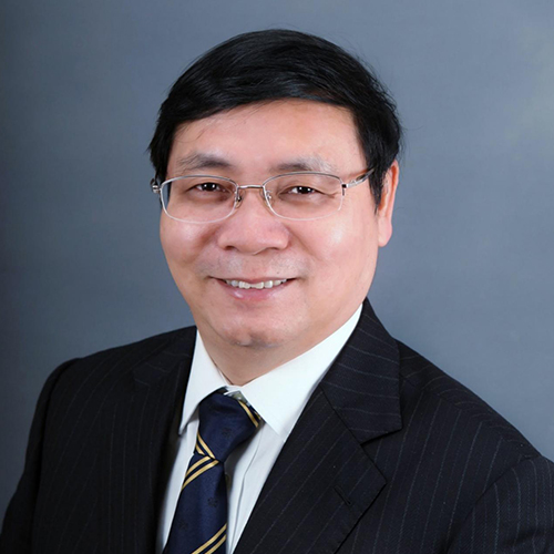
Dr. Jianya Gong is a professor of Wuhan University and an academician of Chinese Academy of Sciences. He is the winner of the National Outstanding Youth Fund, the distinguished Professor of “Changjiang Scholars” of the Ministry of Education, the chief scientist of the 973 Project, the academic leader of the Innovation Group of the National Natural Science Foundation, the leading scientific and technological talents of the State Bureau of Surveying and Mapping, and the convenor of the Surveying and Mapping Discipline Group of the sixth and Seventh Subject Review Groups of The State Council. He was the director of the State Key Laboratory of Information Engineering in Surveying, Mapping and Remote Sensing and the Dean of the school of Remote Sensing Information Engineering of Wuhan University. He has served as ISPRS workgroup chair for three times and was the president of the Commission VI of the International Society of Photogrammetry and Remote Sensing, president of International Association of Chinese Professional in Geographic Information Science. He is currently the Secretary-General of the Asian Association for Geographic Information Systems, associate editor of Acta Geodaetica et Cartographica Sinica and Editor-in-Chief of Journal of Geodesy and GeoInformation Science.
Dr. Jianya Gong is mainly engaged in the research of remote sensing and geographic information system. He has undertaken more than 40 national and provincial scientific research projects. He has published 13 monographs and textbooks, and more than 500 papers. He has won the National Science and Technology Innovation Team Award once, the first prize once and the second prize for 4 times of the National Science and Technology Progress Award, the provincial and ministerial level special prize for 3 times and the first prize for 7 times, and the Dolezal Achievement Award of the International Society of Photogrammetry and Remote Sensing.
In the past few years, satellite-based remote sensing technology has been rapidly developed, the spatial resolution of civilian satellites has reached 0.3m, and the positioning accuracy of post-processing satellites has also reached 3-5m. However, since the data processing system and application mode of existing remote sensing satellites are built according to the delayed processing and application technology system, from uploading instructions to data acquisition, transmission, receiving, processing, and distribution to the application, it needs to go through many processes, often taking several hours or even days to reach the user terminal, which is difficult to meet the immediate user needs. Many remote sensing applications, including disaster emergency and military applications, require immediate response. This keynote speech analyzes the necessity of developing real-time remote sensing satellites and summarizes three key core technologies: real-time and high-precision positioning of satellite remote sensing images, real-time acquisition and transmission of satellite data, and intelligent processing of remote sensing data in orbit. The keynote speech also introduces some experimental studies of Luojia series satellites developed by Wuhan University in the integration of communication, navigation and remote sensing satellite technologies for real-time remote sensing. In the end, the report introduces the plan and progress of the real-time intelligent remote sensing monitoring system – Oriental Smart Eye constellation, which is being established by Wuhan University and Shandong Province.
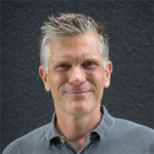
Prof. Dr. Alexander Zipf, is a distinguished GIScientist from Heidelberg University, Chair of the GIScience Group and head of HeiGIT. He is a member of the Centre for Scientific Computing (IWR) and founding member of the Heidelberg Center for the Environment (HCE). His main research areas include Volunteered Geographic Information (VGI), Crowdsourcing, Citizen Science, Analysis and Processing of Geographic Data, and Integrating new methods from Geoinformatics and GIScience in Geography.
Before moving to Heidelberg he led the Chair of Cartography at Bonn University and earlier was Professor for Applied Computer Science and Geoinformatics at the University of Applied Sciences in Mainz, Germany. He has a background in Mathematics and Geography from Heidelberg University.
Volunteered Geographic Information (VGI), esp. OpenStreetMap (OSM), but also crowdsourced street-view imagery, are transforming the landscape of geo-digitalization, offering innovative opportunites for supporting sustainable development. This talk explores the potential of VGI for geo-digitalization, emphasizing its role in sustainable development, esp. with a focus on humanitarian aid and climate action. OpenStreetMap (OSM), as a leading VGI platform, enables participatory mapping, empowering communities to contribute critical geospatial data for disaster response, environmental monitoring, public health and urban planning. The integration of GeoAI – artificial intelligence applied to geospatial data – has the potential to further enhance the efficiency of community-driven mapping efforts. While VGI provides rich, heterogeneous, and local geospatial data, GeoAI offers the potential to generate it more efficiently. The combination of GeoAI and VGI raises questions about data reliability, ethics, and the future of human-AI collaboration in GIScience. Where is the sweet spot between workflows combining crowd intelligence with artificial intelligence? This talk highlights opportunities and challenges and presents selected examples based on the work of HeiGIT and GIScienc Heidelberg with a focus esp. on humanitarian aid and monitoring urban sustainability, contributing to the United Nations’ Sustainable Development Goals (SDGs) by enhancing resilience, environmental stewardship, and humanitarian aid.
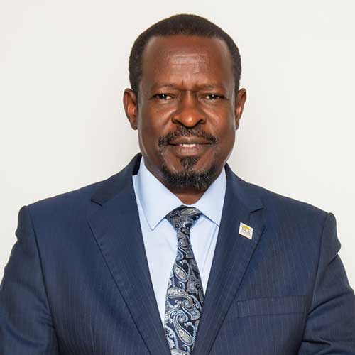
Dr. Emmanuel Nkurunziza is the Director General at the Regional Centre for Mapping of Resources for Development (RCMRD); an intergovernmental organization with 20 contracting member States in Eastern and Southern Africa. He took up this position in the year 2017 after an 8-year tenure as the Director General of Rwanda Natural Resources Authority, a position he held concurrently with that of Chief Registrar of Land Titles. Dr. Nkurunziza provided the technical and strategic direction to the development and implementation of Rwanda’s land reform programme that managed to bring all land in the country under registered title and established a modern land administration system. The titling programme in Rwanda pioneered full-scale implementation of what are now generally referred as fit-for-purpose land administration techniques and approaches.
Dr. Nkurunziza’s academic background is in Land Surveying but holds a master’s degree in urban planning from the University of Wales (Cardiff) and PhD in Public Policy from the University of Birmingham (UK). He began his career in the academia, having worked in various roles as Research Fellow and Lecturer in the University of Makerere (Uganda) and Birmingham (UK).